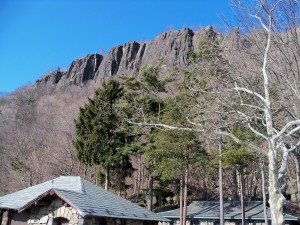
 This past Sunday the Philmont crew went on a day hike on the NJ Palisades. The Palisades are a cliff face between the George Washington Bridge and the Tappen Zee Bridge. The cliffs are about 600 high. The hike traversed along the base of the cliffs right next to the Hudson river and then climbed to the top and followed the cliff edge back to the starting point.
We started the hike at the Palisades Interstate Commission Office by Exit 2 on the Palisade Parkway. The weather was great. Temps were in the 50’s, skies were clear blue.
 Along the base of the cliffs there was absolutely no snow. The trail took us through the public boat launch, which was closed this time of year. At a trail intersection we had a 20 minute “packs off” break. While at this break we studied the map that we had with us to make sure we “knew” where we were. The map we had was very poor. But the thinking was we couldn’t get lost because we were right next to the Hudson river. Bad thinking.
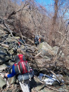
Turns out that the intersection we had our break at was the intersection we should have taken to get back to the top of the cliffs. Instead we continued along the base of the cliffs heading north. We came to the giant steps, which we mistakenly believed led back to the top of the cliffs. Instead the giant steps was a massive boulder field with rocks the size of cars and trailers. The giant steps were leaps to the next rock. This field of boulders was about 3/4 of a mile long and took us 1 1/2 hours to cross. Also along the path the recent storms toppled dozens of large trees across the trail. There were places that we had to pass the backpacks to each other so we could climb over and under the obstacles. It was great to see the crew really working together to overcome the challenges. The teamwork was excellent!!
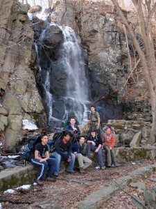
 We went about another mile before we realized that we made a mistake. At that point we had 3 more miles moving forward or traverse back through the mess/maze of trees and rocks. The crew elected to continue forward to the waterfall and then climb up the cliff face. All in all this slight navigational error added 5 miles to a 7.5 mile hike.
As we made our way to the top of the cliffs, the snow gradually became deeper. At this point we were all tired. The snow made the progress all the more difficult. When we reached the Lookout Inn, I went and bought a real set of maps for the trail. Yes, it was after the damage was done, but the maps will come in handy on future hikes. We ended up hiking back on Route 9 heading south to avoid the snow and allow us to get back to the cars at a reasonable pace. As it was originally we thought we would be done by 1pm. Instead we completed the hike around 3:30pm.
If you haven’t hiked along the Palisades, I would highly recommend it. The views were spectacular, both from the base of the cliffs and from the top. I would also highly recommend you plan to follow the trail through the giant steps and by the waterfall. Our navigational error took us through some awesome scenery and resulted in a hike that was adventurous! If we had stayed on our original plan, I sincerely believe this hike would have been a mediocre, less than memorable hike. I would also suggest you use a real map and not a guide book 😉